IPSDI Analytics
Transforming Public Safety Operations Through Data
Performance Monitoring
Monitor your call processing, alarm handling, turnout time, and more in real-time. You'll always know whether you're meeting standards and where you can improve.
Common Addresses
By knowing where and why your resources are dispatched the most, you can respond more efficiently; and take more effective preventative measures to reduce call volume.
Daily Email Reports
Daily, weekly, and monthly performance summaries delivered directly to your inbox at the end of each shift for maximum situational awareness.
Advanced Analytics
Need help calculating effective response force times, or measuring the impact of simultaneous incidents on your response system? Let IPSDI Analytics do the heavy lifting.
Empowering Smarter
Public Safety
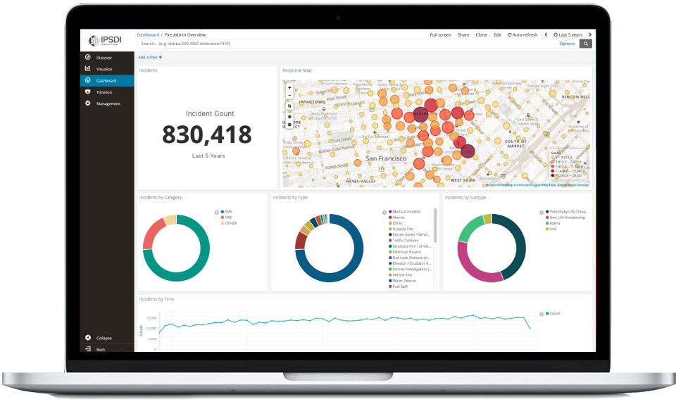
Your Incident Response Data
Your response data is automatically pulled into the app from your RMS or CAD system, providing near real-time overview of your operations. Multiple data sources (including scheduling) can be combined for a detailed operational overview.
Accreditation Made Easy
Prebuilt reports automate the data collection and formatting for accreditation report generation. Our reports streamline both initial and ongoing accreditation cycles by providing the necessary data quickly with minimal effort.
Social Vulnerability, Defined
Analyze the connection between incident response locations and the Social Vulnerability Index (SVI) to prioritize your Community Risk Reduction programs. Identify the areas of your community that will directly benefit from increased outreach.
Enhanced Exposure Tracking
Validated members of your department will receive incident details in the IPSDI Exposure Tracker app, allowing them to quickly import the correct address, incident number, time on scene, and weather conditions.
Unit Response Details
Easily identify unit performance and workload, and find areas where improvement can be made. Could busy districts benefit from additional peak-time staffed units? See how often the first-due apparatus wasn't available.
Weather and GIS Enrichment
Importing GIS shapefiles provides context for your incident locations. Overlay boundaries such as first-due areas, battalions, or city council districts, and more. Detailed weather conditions at your incident offer insight to the environmental impact.
Transform Your Operations: See IPSDI Analytics Live.
Schedule a personal demo to see how IPSDI Analytics delivers immediate operational insight and learn about its full capabilities.
Schedule Your Live Demo